AN ALTERNATIVE INCA TRAIL (IN BOLIVIA!)
The rewards of getting off the beaten track on a 3000 metre descent from the barren heights of the Andes to the lush Amazon Basin.
The taxi's engine hummed in the cold mountain air. I stood and wondered if I'd be OK with the altitude and my heart started racing not for the first time that day. Our driver had pulled over to let me relieve myself and I was now seriously doubting what we'd let ourselves in for. A dark lake lay below me reflecting my mood, its surface rippled by the keen winds whipping off the high peaks to the north. We were already at 4000m and still had a way to go to the trailhead at El Cumbre almost 1000m higher up the road. I jumped back in the passenger seat of the aging car we'd hailed back in La Paz and we started to climb the last few kilometres to the pass.
We'd opted to kill two birds with one stone and hike down from the heights of the Cordillera Real to Coroico thus experiencing one of Bolivia's most beautiful treks along paved pre-Columbian Inca roads and avoiding a section of highway popularly know as "the world's most dangerous road". It had won this infamous accolade on account of its regular fatal accidents usually involving buses in various states of disrepair going off the edge and plummeting several thousand feet to the valley floor. There was, of course, the option of tearing down said road on a bike but the idea of missing out on the superlative scenery as it whipped by in a blur surrounded by a bunch of adrenalin junkies didn't sound appealing so my girlfriend and I had chosen the trek.
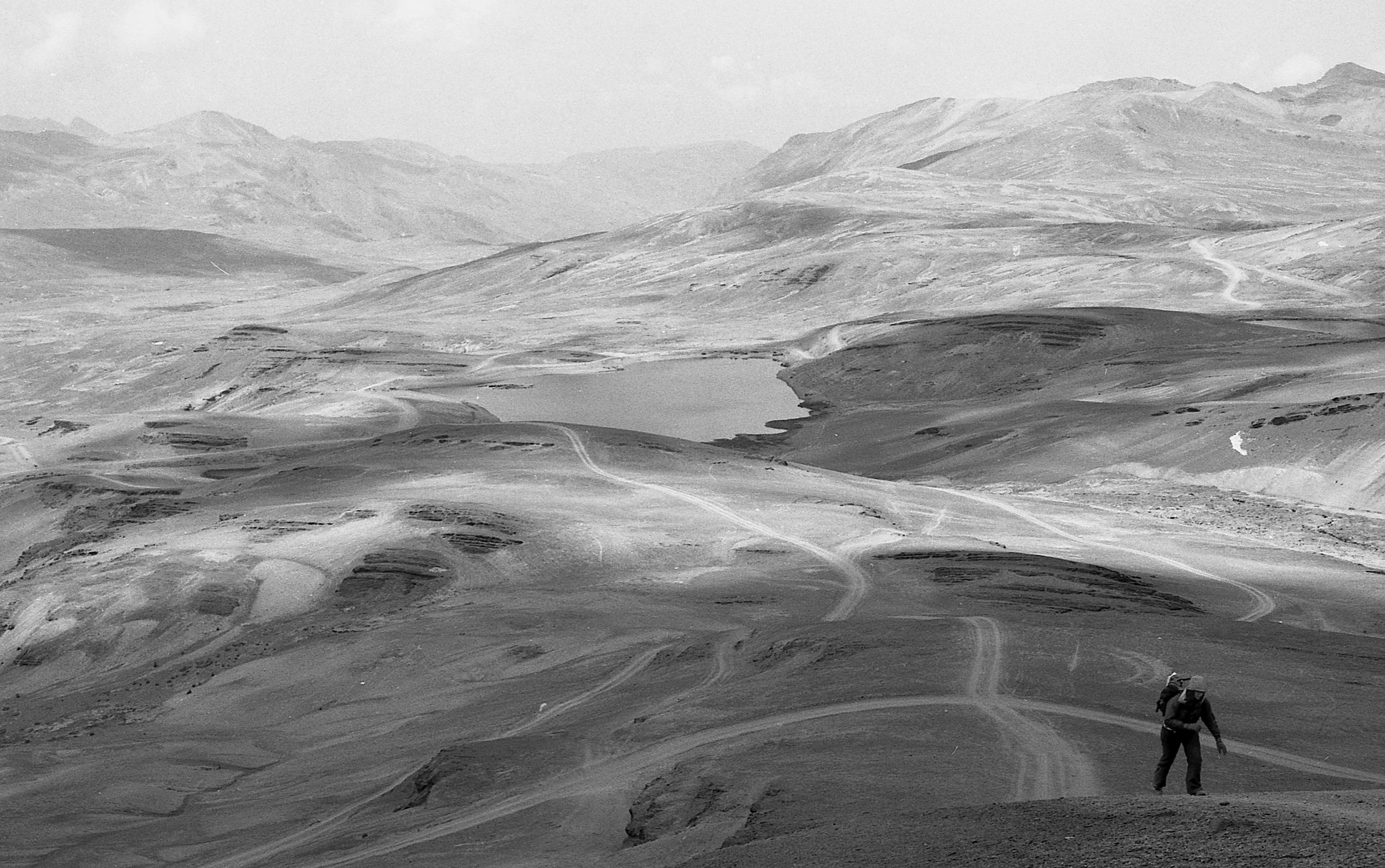
At the pass the taxi pulled away, made a u-turn and began its descent back down to the capital. We were alone with not a living thing in sight. Barren brown treeless slopes punctuated with shrinking patches of snow and ice surrounded us. This lunar landscape stretched out and met with splintered rock peaks on all sides whilst billowing cloud blown up from the lowlands swirled and danced above and below us. The air was thin and as we set off we were finding it difficult to catch our breath, at 4700 this was the highest we'd ever been but thankfully the telltale signs of altitude sickness had not kicked in.
We made our way to a rangers hut about 500m from the road and signed the logbook. As we scrawled our names and details on the crumpled page I had the feeling I was signing out of the known world and about to embark on a journey into the unfamiliar, the "other". Two couples and their guides had signed out in the last few days but that was it; word was not yet out about this route meaning the crowds that flocked to the Inca Trail and Macchu Pichu were, for the moment at least, far far away. The feeling of walking into the unknown was further compounded by the fact we'd chosen to do this alone, without a guide, in an attempt to embrace wholeheartedly the spirit of adventure. There would be no hostels or guesthouses, no electricity or running water. For the next three days we were on our own with only the things we carried on our backs.
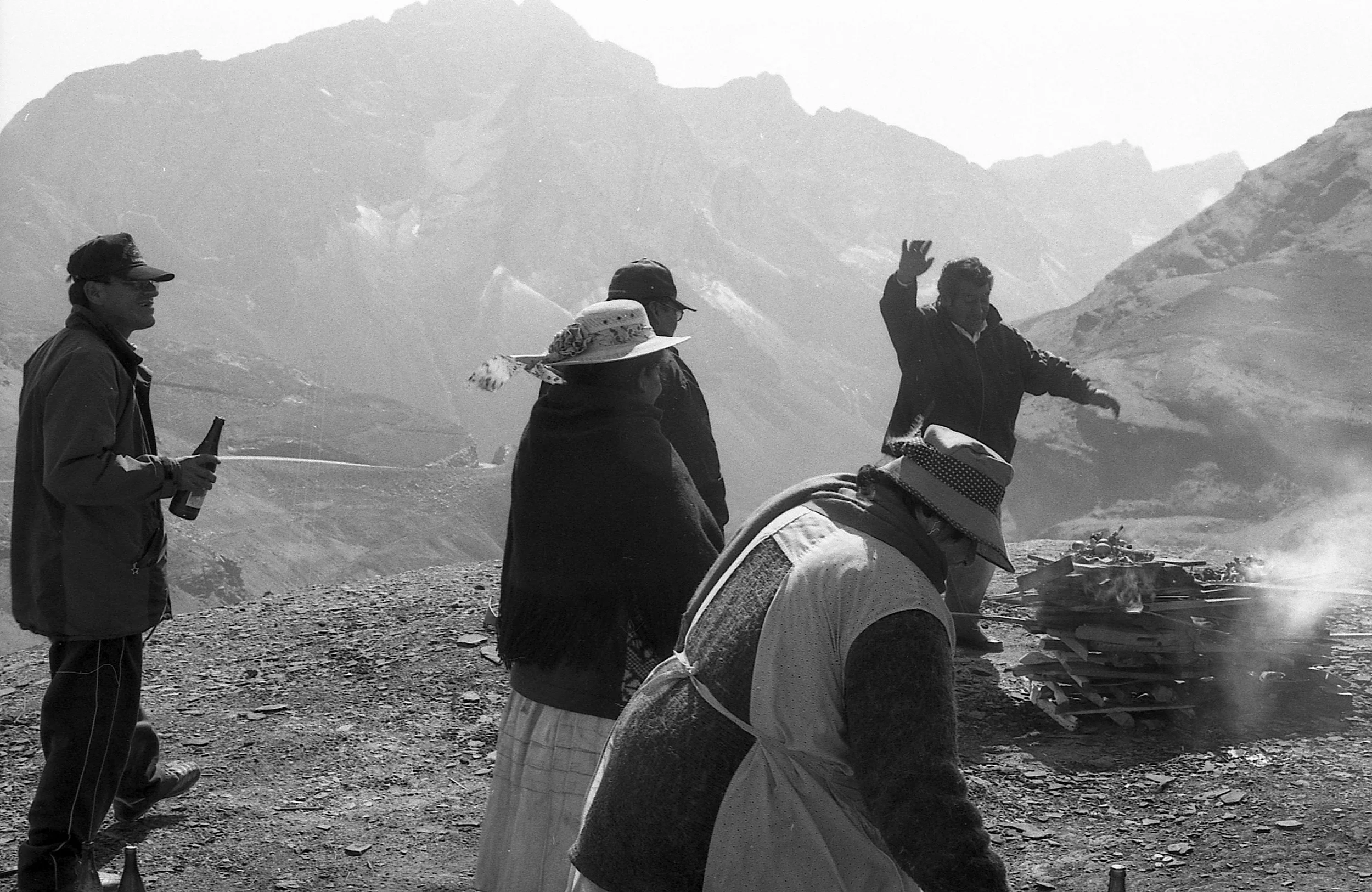
Looking back, the most physically demanding part of the 70kms we covered was that first climb up from El Cumbre to Abra Chucura, a small notch in the hillside above us at almost 5000m. The wending 2km track over stony ground and between small ponds took at least an hour as our overworked lungs and thumping hearts did their best to carry us up to the highest point on our trek. It was cold and the wind was biting at our faces. On the way we passed a small shrine where some locals where making offerings of alcohol and cigarettes to Pachamama, the goddess revered by the indigenous people of the Andes. As I made eye contact with one of the men and nodded a "buenos días" he passed me a bottle of what was near pure alcohol to make our own offering to the gods. In light of what we were doing it seemed like a good idea to partake in the ceremony. Bidding our farewells we eventually made it to Abra Chucura, we were stood at the watershed of the mighty Andes, from here it was downhill all the way to the Amazon Basin.
In Inca times the route that lay ahead had been one of three important highways connecting the "Altiplano", a high plateau that covers almost half of all Bolivia, and the lower subtropical region known as Las Yungas. It is generally thought that their rock pavement, drainage channels and enclosed walls are more impressive than similar roads in Peru and while it is not certain who created these roads they are definitely known to have been already in existence before the conquest of the region by the Incas. I stood and pondered; how many people had walked these flagstones over the centuries? Civilizations had come and gone but still this line through the folds in the mountains endured. What would we encounter on our journey? There was only one way to find out...
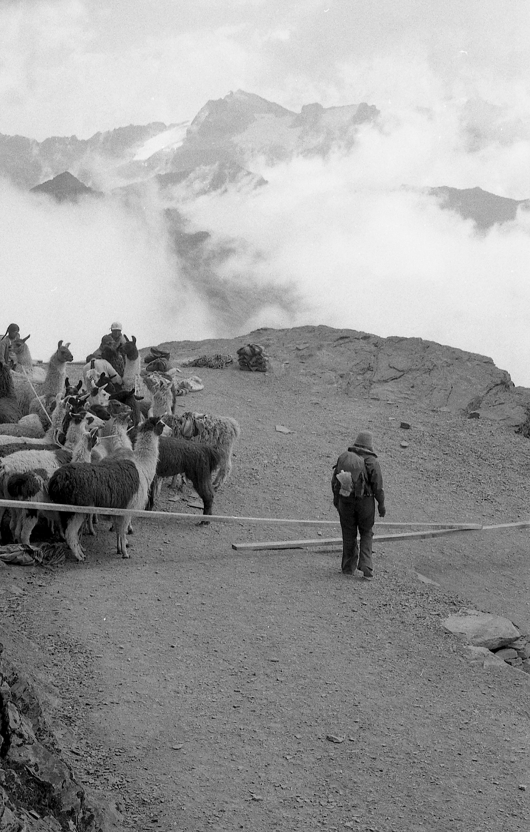
The next few hours were incredible. Mile upon mile of ancient paving dropped out of the mountains as we lost altitude. We passed Llama farmers driving their stock up from the valleys below to market in La Paz. Later a lone man passed us carrying a huge beam of wood attached to his head with rope, presumably for a building project in a village further down the trail. As we went through small settlements children would run out to greet us, smiling through their grubby faces and tattered clothes. This was a land completely cut off from the outside world. Self-sufficiency was key to survival here with anything else having to be brought in on foot or by mule. The landscape was changing too; bare rock was turning to tufts of tuff grass which in turn morphed into pasture. As morning turned into afternoon, we spotted our first tree. Birdsong met us on the wind and before long we were walking through woods with the sounds of water gurgling and spitting as it tumbled alongside us.
By late afternoon we'd reached the small hamlet of Challapampa. At 2825m this was to be our stop for the night. We pitched our tiny tent next to the river, made a quick dinner of noodles on our stove and turned in exhausted.
Dawn and the sound of a roaring river, birds chattering and a still, chilly air. With stiff backs and aching limbs we packed away our things, gobbled down a cereal bar and were on our way. The day was to be an epic and long one of 10 hours hard walking. We spent the first 2 hours slipping and sliding our way down the beautifully paved pre-Columbian road that ran alongside the spilling and sputtering Rio Chucura to Choro, an idyllic collection of thatched adobe houses huddled on steep and narrow terraces cut into the mountainside. The air was humid and sticky and the vegetation around us was a vivid green. We were both sweating and starting to lose liquid fast; over the next 8 hours keeping hydrated was to be our primary concern.
We left Choro crossing its wooden slatted suspension bridge and turned east where the Rio Chucura met the Tiquimani. The trail now entered a section of dense vegetation where water was scarce. We were starting to get hungry but our supplies were low and we had to make do with a packet of biscuits between us for the remainder of the day and collecting and purifying water whenever the track dropped down to cross a tributary. We wound around fold after fold along the valley-side keeping more or less to the 2000m contour line with regular descents and climbs out of gullies and gorges, fording their respective watercourses. Late in the afternoon we passed through the tiny hamlets of San Francisco and Buena Vista where dogs nipped at our ankles and chickens roamed freely. People greeted us as we passed their straw houses, miles from anywhere but surrounded by everything they could possibly need. Hummingbirds hovered at the side of the trail, a sure sign we were entering a more tropical climate. The light faded, our torches came out and we pushed our way through long head-high grasses wondering if we'd ever make our destination for our night's stop. We finally made it in the pitch black and pitched our tent.
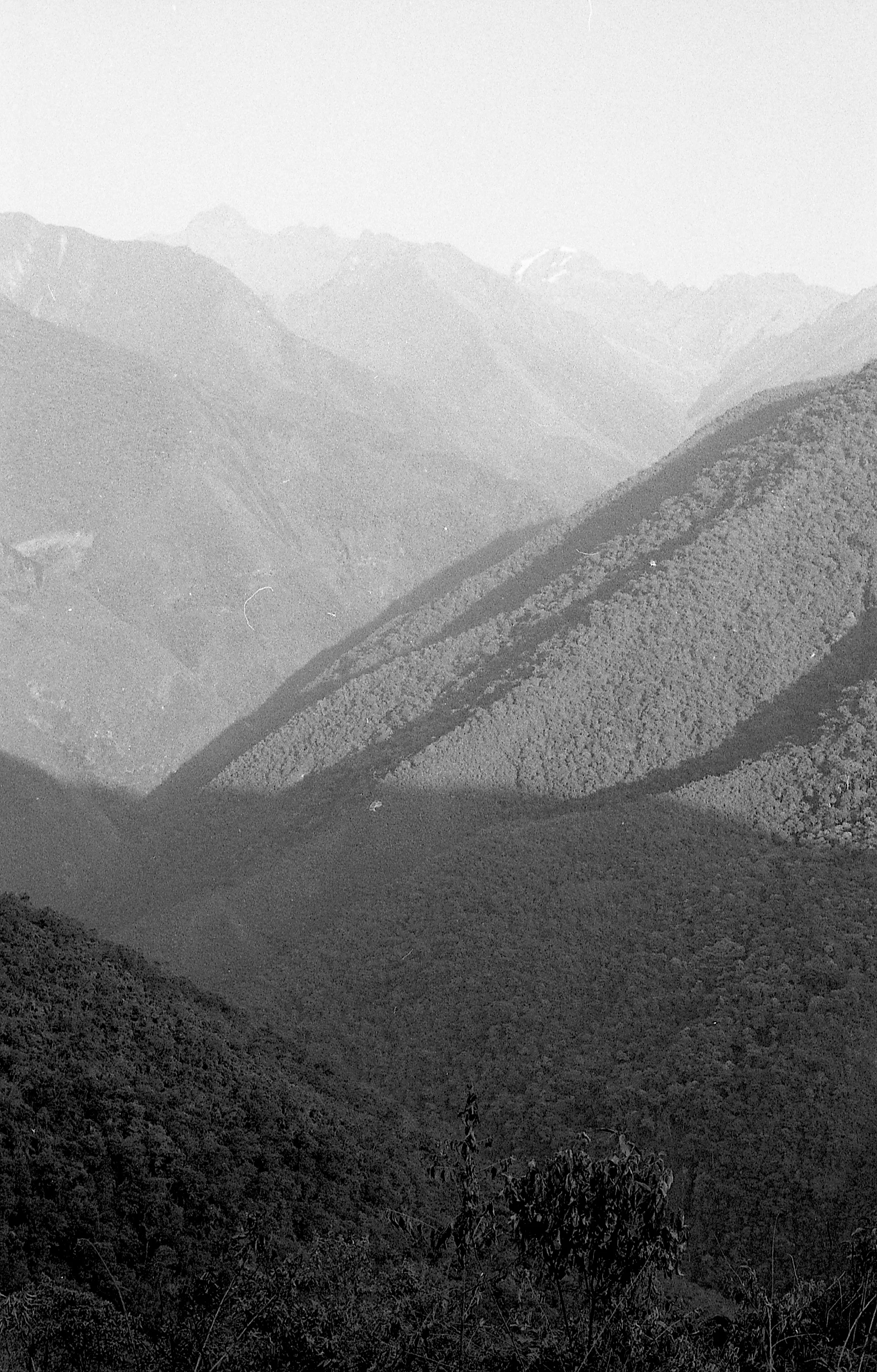
I'll never forget the view I unzipped from our tent that morning. Layer upon layer of lush green, forested mountainside backed by a few more layers of serrated sierras and finally, looming over everything at what seemed like the back of the sky, the glacier-cloaked6000m plus peak of Huayna Potosí. The rising sun shining from behind us lit up each part of the scene from top to bottom in succession before hitting our tent and enticing us out for our breakfast of yet more biscuits. It got hot, quick. Before long we were on the move once more and descending to the village of Chairo, the main road and civilization.
Hitching a ride proved to be incredibly easy and within 10 minutes of our arrival in the village we were bouncing and bumping our way along the dirt track that followed the valley floor to Coroico in the back of a pick-up which had seen better days. Sat on my backpack I reflected on the past 3 days; we'd avoided a bus ride from hell down the "world's most dangerous road", yes, but we'd also done so much more. We'd found a pocket of Bolivia that most travellers would never experience. We'd fallen off the roller-coaster ride that is the "gringo trail" and seen things at a slower pace. We hadn't signed up for some activity that others felt almost obliged to do, like they would have missed out on something had they not done it. All too often we, independent travellers, backpackers, follow the crowd in an attempt to tick off as many things from our list as possible; sky dive, bungee jump, white water rafting, adrenalin fuelled this and testosterone charged that. This had been different. This had been real. I'd looked deep into the eyes of the country. I'd tasted what it really means to travel and I wanted more.